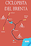
Detailed directions about the route can be obtained from the altimetry (last figure of the gallery), from the captions of the individual photos and from the "Google Map" at the bottom right, which can be enlarged as desired. Double clicking on the photos you can view them at the highest resolution.
Description of the route
This route recalls to a large degree the route I published in 2008 from Levico to Bassano. The major change as of 2014 is the opening of a new section of bike path between Ospedaletto and Tezze, paved and entirely along the Brenta River, and which replaces the section along designated local roads. A great step ahead towards a 100% dedicated bike path between Trento and Bassano. What is still lacking is an acceptable bike route between Pergine and Trento; there is a plan for this section which has been postponed indefinitely for lack of funds (and above all political will). [Sound familiar, fellow Americani? RB]
Point of departure is the train station at Pergine; exit through the main section of the station and get on the bike lane on the far side of the street and head right; from here the GPS trace shows a route using local roads that takes one to Lago [lake] di Caldonazzo and the village of Calceranica. One could also exit the station from the back and take the small street to the left which would also eventually join up with the GPS indicated route.
Following the local roads one arrives at an underpass which marks the beginning of the true dedicated bike path. Shortly afterwards begins the section along the lake, in part on dedicated bike path, and in part on local roads and streets. Once we are past the lake we travel through a vast area of apple orchards.
Once we are past the apple orchards we need to go across the road that goes to Levico at which point begins a long stretch almost entirely on dedicated bike path all the way to Borgo Valsugana. Once there, cut through the middle of the village and then continue along the Brenta, once again, until you reach the end of the village marked by the train station Borgo Valsugana Est.
From Borgo the bike route runs almost entirely along the Brenta with several small bike bridges crossing its many tributaries. At Ospedaletto we continue along the new section (2014) which runs in a gradual descent along the river as far as Tezze, where the bike path ends in front of a steel bridge; crossing it one arrives back onto local roads; traffic is limited but the road is narrow and still cause to pay attention.
After you pass the side-road to Primolano there is another section of bike path that runs through a narrow gorge as far as Enego, at which point the bike path ends definitively at a bridge over the Brenta. Continue along the road on the right bank of the Brenta which is relatively peaceful; one could continue all the way to Bassano del Grappa (the final miles become increasingly busy with traffic), or one can conclude this route at one of the several train stations just across the river: Cismon del Grappa, San Marino, or Carpanè Valstagna. The GPS trace shows the route as far as the last station.
Obviously one can take this route in the opposite direction, with much of the duration going up a very gentle climb. Travel times for both directions can be calculated on the page which shows time durations, map and altimetry.