| Place | Altitude
m s.l.m. | Distance
m | Dist.prog.
km
| Accumulative
expected time | Hour
You will pass here | Google Map
|
|---|
|
|
Conversions
| Pounds to kilograms (kg) | Multiply pounds x .4536 = kilograms |
| Miles to kilometers (km) | Multiply miles x 1.6 = kilometers |
| Kilometers to miles | Multiply kilometers x .6 = miles |
| Meters to feet | Multiply meters x 3.3 = feet
|
|
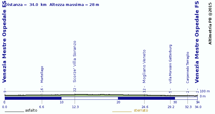
| Venezia Mestre Ospedale FS | 9 m | 0 m | 0.0 km | 0:00 | 12:00 |
| innesto su via Castellana | 10 m | 2192 m | 2.2 km | 0:06 | 12:06
|
| Martellago | 16 m | 4385 m | 6.6 km | 0:19 | 12:19
|
7.498 km 16 m s.l.m.
45.5471, 12.1549")'>Ca' della Nave | 16 m | 921 m | 7.5 km | 0:22 | 12:22
|
12.325 km 22 m s.l.m.
45.5703, 12.1083")'>Scorze' Villa Soranzo | 22 m | 4827 m | 12.3 km | 0:36 | 12:36
|
12.698 km 26 m s.l.m.
45.5734, 12.1083")'>Scorze' chiesa San Benedetto | 26 m | 373 m | 12.7 km | 0:37 | 12:37
|
| Cappella | 24 m | 3861 m | 16.6 km | 0:48 | 12:48
|
| Mogliano Veneto | 12 m | 8049 m | 24.6 km | 1:09 | 13:09
|
| villa Marcello-Giustinian | 7 m | 3299 m | 27.9 km | 1:19 | 13:19
|
| villa Morosini Gatterburg | 5 m | 1295 m | 29.2 km | 1:22 | 13:22
|
| Carpenedo Terraglio | 2 m | 3058 m | 32.3 km | 1:31 | 13:31
|
| Venezia Mestre Ospedale FS | 2 m | 1699 m | 34.0 km | 1:35 | 13:35
|
| Total | 34.0 km | 01 h 35 m
|
|---|
|